News
Flyer: International Volksmarch Filderstadt/Stuttgart (SGAWC) on 20 September 2026
Event list DVV walks July-December 2026
Event list DVV walks July-December 2026
Upcoming SGAWC Events and annual DVV Walks
Subscribe our events list with your calendar app!
Show all walks on a map
- Club Meeting & Council Meeting - Stuttgart-Vaihingen
Start: 19:00 hours - End: 22:00 hours - Address: Römerhof, Robert-Leicht-Straße 93, 70563 Stuttgart-Vaihingen - Club Homepage - GPS coordinates: 48.73866,9.10676 - OpenStreetMap - Google Maps - Public Transport Stop: Stuttgart Universität (Deutsche Bahn) (12 minutes footway) - All members always welcome! - Dinner available from 1800.
Weather at the Event location:
Expected weather during the event:
7pm: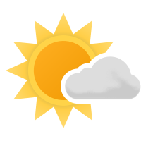 Fair sky / Temperature: 20.2℃ = 68.36℉ / Wind speed: 11.52 km/h / 7.1584 mph - Light breeze
8pm: Clear blue sky / Temperature: 19.1℃ = 66.38℉ / Wind speed: 9 km/h / 5.5925 mph - Gentle breeze
9pm: Clear blue sky / Temperature: 16.7℃ = 62.06℉ / Wind speed: 7.92 km/h / 4.9214 mph - Gentle breeze
10pm: Clear blue sky / Temperature: 15.4℃ = 59.72℉ / Wind speed: 7.92 km/h / 4.9214 mph - Gentle breeze
11pm: Clear blue sky / Temperature: 14.8℃ = 58.64℉ / Wind speed: 7.92 km/h / 4.9214 mph - Gentle breeze
Maximum temperature: 20.2℃ / 68.36℉
Lowest temperature: 14.8℃ / 58.64℉
Weather data from MET Norway - Last updated: 20.07.2026 15:16:04
Weather icons: Copyright © 2015-2017 by Yr and licensed under MIT License
- Crailsheim-Jagstheim / Wanderfreunde Crailsheim e.V. / Baden-Württemberg - Stammtisch
Trails: 6/11/21/30 km - Start: 06:00 - 13:00 hours - End: 17:00 hours - Address: Jagstauenhalle, Jagstheimer Hauptstraße 157, 74564 Crailsheim-Jagstheim - Club Homepage - GPS coordinates: 49.08953,10.06458 - OpenStreetMap - Google Maps - Public Transport Stop: Jagstheim Ortsmitte, Crailsheim (Deutsche Bahn) (4 minutes footway or Shuttle service only if reservated from railway stop Crailsheim) - Download Flyer
Weather at the Event location:
Expected weather during the event:
8am: Fair sky / Temperature: 16.4℃ = 61.52℉ / Wind speed: 12.96 km/h / 8.0532 mph - Light breeze
2pm: Cloudy sky / Temperature: 27.2℃ = 80.96℉ / Wind speed: 9 km/h / 5.5925 mph - Gentle breeze
Maximum temperature: 27.2℃ / 80.96℉
Lowest temperature: 16.4℃ / 61.52℉
Weather data from MET Norway - Last updated: 20.07.2026 15:15:43
Weather icons: Copyright © 2015-2017 by Yr and licensed under MIT License
- Crailsheim-Jagstheim / Wanderfreunde Crailsheim e.V. / Baden-Württemberg - Stammtisch
Trails: 6/11/21/30 km - Start: 06:00 - 13:00 hours - End: 17:00 hours - Address: Jagstauenhalle, Jagstheimer Hauptstraße 157, 74564 Crailsheim-Jagstheim - Club Homepage - GPS coordinates: 49.08953,10.06458 - OpenStreetMap - Google Maps - Public Transport Stop: Jagstheim Ortsmitte, Crailsheim (Deutsche Bahn) (4 minutes footway or Shuttle service only if reservated from railway stop Crailsheim) - Download Flyer
Weather at the Event location:
Expected weather during the event:
8am: Fair sky / Temperature: 18℃ = 64.4℉ / Wind speed: 12.24 km/h / 7.6058 mph - Light breeze
2pm: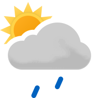 Light Rain showers - Rainfall amount: 0.1 l/m² / Temperature: 25.2℃ = 77.36℉ / Wind speed: 16.92 km/h / 10.5139 mph - Light breeze
Maximum temperature: 25.2℃ / 77.36℉
Lowest temperature: 18℃ / 64.4℉
Weather data from MET Norway - Last updated: 20.07.2026 15:15:43
Weather icons: Copyright © 2015-2017 by Yr and licensed under MIT License
- Kämpfelbach-Ersingen / Wanderfreunde Kämpfelbachtal e.V. / Baden-Württemberg
Trails: 5/10/20 km - Start: 08:00 - 13:00 hours - End: 16:00 hours - Address: Turn- und Festhalle, Turnstraße 4, 75236 Kämpfelbach-Ersingen - GPS coordinates: 48.93280,8.63073 - OpenStreetMap - Google Maps - Public Transport Stop: Ersingen West (Deutsche Bahn) (4 minutes footway)
- Kämpfelbach-Ersingen / Wanderfreunde Kämpfelbachtal e.V. / Baden-Württemberg
Trails: 5/10/20 km - Start: 07:30 - 13:00 hours - End: 16:00 hours - Address: Turn- und Festhalle, Turnstraße 4, 75236 Kämpfelbach-Ersingen - GPS coordinates: 48.93280,8.63073 - OpenStreetMap - Google Maps - Public Transport Stop: Ersingen West (Deutsche Bahn) (4 minutes footway)
- Club Meeting - Stuttgart-Vaihingen
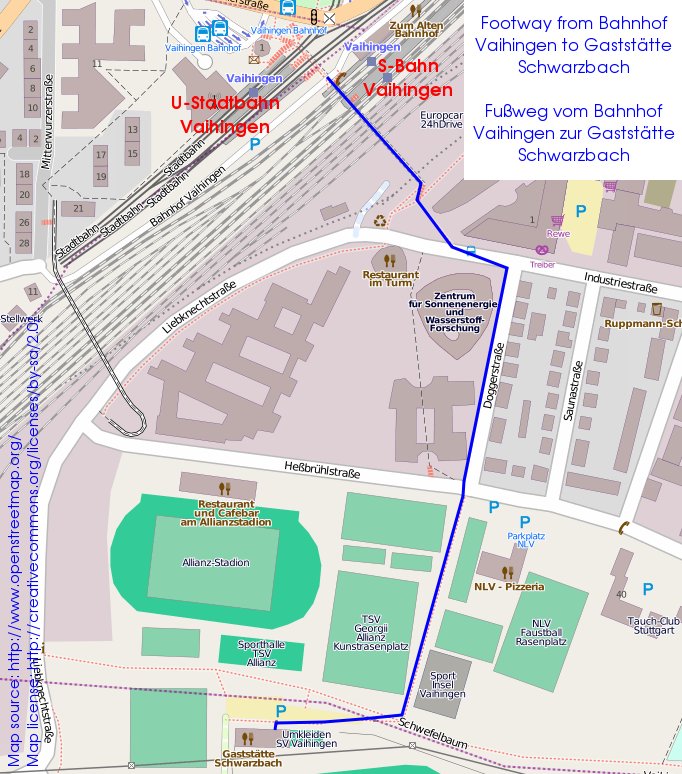
Start: 19:00 hours - End: 22:00 hours - Address: Gaststätte Schwarzbach, Dürrlewangstraße 70, 70565 Stuttgart - Club Homepage - GPS coordinates: 48.72182,9.11198 - OpenStreetMap - Google Maps - Public Transport Stop: Stuttgart-Vaihingen (Deutsche Bahn) (6 minutes footway directions) - Guests always welcome! - Dinner available from 1800.
- Filderstadt-Plattenhardt (SGAWC) - Pre-Walk - IVV credit only for walk volunteers!
Trails: 5 km - Start: 08:45 hours - Address: Weilerhauhalle, Weilerhau 2, 70794 Filderstadt-Plattenhardt - Club Homepage - GPS coordinates: 48.654063,9.187771 - OpenStreetMap - Google Maps - Public Transport Stop: Plattenhardt Weilerhau, Filderstadt (Deutsche Bahn) (4 minutes footway)
Contact: Andy Osborn
- Filderstadt-Plattenhardt (SGAWC) - Pre-Walk - IVV credit only for walk volunteers!
Trails: 10 km - Start: 08:45 hours - Address: Weilerhauhalle, Weilerhau 2, 70794 Filderstadt-Plattenhardt - Club Homepage - GPS coordinates: 48.654063,9.187771 - OpenStreetMap - Google Maps - Public Transport Stop: Plattenhardt Weilerhau, Filderstadt (Deutsche Bahn) (4 minutes footway)
Contact: Andy Osborn
- Council Meeting - Stuttgart-Vaihingen
Start: 19:00 hours - End: 22:00 hours - Address: Römerhof, Robert-Leicht-Straße 93, 70563 Stuttgart-Vaihingen - Club Homepage - GPS coordinates: 48.73866,9.10676 - OpenStreetMap - Google Maps - Public Transport Stop: Stuttgart Universität (Deutsche Bahn) (12 minutes footway) - All members always welcome! - Dinner available from 1800.
- Filderstadt-Plattenhardt (SGAWC) - Pre-Walk - IVV credit only for walk volunteers!
Trails: 10 km - Start: 08:45 hours - Address: Weilerhauhalle, Weilerhau 2, 70794 Filderstadt-Plattenhardt - Club Homepage - GPS coordinates: 48.654063,9.187771 - OpenStreetMap - Google Maps - Public Transport Stop: Plattenhardt Weilerhau, Filderstadt (Deutsche Bahn) (4 minutes footway)
Contact: Andy Osborn
- Club Meeting - Stuttgart-Vaihingen
Start: 19:00 hours - End: 22:00 hours - Address: Gaststätte Schwarzbach, Dürrlewangstraße 70, 70565 Stuttgart - Club Homepage - GPS coordinates: 48.72182,9.11198 - OpenStreetMap - Google Maps - Public Transport Stop: Stuttgart-Vaihingen (Deutsche Bahn) (6 minutes footway directions) - Guests always welcome! - Dinner available from 1800.
- Erstein / Les Marcheurs du Sucre / France
- Freiamt-Mußbach / Motorsport Racing-Team Freiamt e.V. / Baden-Württemberg
Trails: 6/12/16 km - Start: 07:00 - 13:00 hours - End: 16:00 hours - Address: Festzelt at the Clubhaus Motorsport Racing-Team, Am Bus 57, 79348 Freiamt-Mußbach - Club Homepage - GPS coordinates: 48.17342,7.89359 - OpenStreetMap - Google Maps - Download Flyer
- Freiamt-Mußbach / Motorsport Racing-Team Freiamt e.V. / Baden-Württemberg - GPS-DVV-Walk - Smart phone with GPS-App needed!
Trails: 30 km - Start: 07:00 - 10:00 hours - End: 16:00 hours - Address: Festzelt at the Clubhaus Motorsport Racing-Team, Am Bus 57, 79348 Freiamt-Mußbach - Club Homepage - GPS coordinates: 48.17342,7.89359 - OpenStreetMap - Google Maps - Download Flyer
Show all DVV walks in BW...
Show all walks on a map
- Club Meeting & Council Meeting - Stuttgart-Vaihingen
Start: 19:00 hours - End: 22:00 hours - Address: Römerhof, Robert-Leicht-Straße 93, 70563 Stuttgart-Vaihingen - Club Homepage - GPS coordinates: 48.73866,9.10676 - OpenStreetMap - Google Maps - Public Transport Stop: Stuttgart Universität (Deutsche Bahn) (12 minutes footway) - All members always welcome! - Dinner available from 1800.
Weather at the Event location:
Expected weather during the event:
7pm:
8pm:
9pm:
10pm:
11pm:
Maximum temperature: 20.2℃ / 68.36℉
Lowest temperature: 14.8℃ / 58.64℉
Weather data from MET Norway - Last updated: 20.07.2026 15:16:04
Weather icons: Copyright © 2015-2017 by Yr and licensed under MIT License
- Crailsheim-Jagstheim / Wanderfreunde Crailsheim e.V. / Baden-Württemberg - Stammtisch
Trails: 6/11/21/30 km - Start: 06:00 - 13:00 hours - End: 17:00 hours - Address: Jagstauenhalle, Jagstheimer Hauptstraße 157, 74564 Crailsheim-Jagstheim - Club Homepage - GPS coordinates: 49.08953,10.06458 - OpenStreetMap - Google Maps - Public Transport Stop: Jagstheim Ortsmitte, Crailsheim (Deutsche Bahn) (4 minutes footway or Shuttle service only if reservated from railway stop Crailsheim) - Download Flyer
Weather at the Event location:
Expected weather during the event:
8am:
2pm:
Maximum temperature: 27.2℃ / 80.96℉
Lowest temperature: 16.4℃ / 61.52℉
Weather data from MET Norway - Last updated: 20.07.2026 15:15:43
Weather icons: Copyright © 2015-2017 by Yr and licensed under MIT License
- Crailsheim-Jagstheim / Wanderfreunde Crailsheim e.V. / Baden-Württemberg - Stammtisch
Trails: 6/11/21/30 km - Start: 06:00 - 13:00 hours - End: 17:00 hours - Address: Jagstauenhalle, Jagstheimer Hauptstraße 157, 74564 Crailsheim-Jagstheim - Club Homepage - GPS coordinates: 49.08953,10.06458 - OpenStreetMap - Google Maps - Public Transport Stop: Jagstheim Ortsmitte, Crailsheim (Deutsche Bahn) (4 minutes footway or Shuttle service only if reservated from railway stop Crailsheim) - Download Flyer
Weather at the Event location:
Expected weather during the event:
8am:
2pm:
Maximum temperature: 25.2℃ / 77.36℉
Lowest temperature: 18℃ / 64.4℉
Weather data from MET Norway - Last updated: 20.07.2026 15:15:43
Weather icons: Copyright © 2015-2017 by Yr and licensed under MIT License
- Kämpfelbach-Ersingen / Wanderfreunde Kämpfelbachtal e.V. / Baden-Württemberg
Trails: 5/10/20 km - Start: 08:00 - 13:00 hours - End: 16:00 hours - Address: Turn- und Festhalle, Turnstraße 4, 75236 Kämpfelbach-Ersingen - GPS coordinates: 48.93280,8.63073 - OpenStreetMap - Google Maps - Public Transport Stop: Ersingen West (Deutsche Bahn) (4 minutes footway)
- Kämpfelbach-Ersingen / Wanderfreunde Kämpfelbachtal e.V. / Baden-Württemberg
Trails: 5/10/20 km - Start: 07:30 - 13:00 hours - End: 16:00 hours - Address: Turn- und Festhalle, Turnstraße 4, 75236 Kämpfelbach-Ersingen - GPS coordinates: 48.93280,8.63073 - OpenStreetMap - Google Maps - Public Transport Stop: Ersingen West (Deutsche Bahn) (4 minutes footway)
- Club Meeting - Stuttgart-Vaihingen
Start: 19:00 hours - End: 22:00 hours - Address: Gaststätte Schwarzbach, Dürrlewangstraße 70, 70565 Stuttgart - Club Homepage - GPS coordinates: 48.72182,9.11198 - OpenStreetMap - Google Maps - Public Transport Stop: Stuttgart-Vaihingen (Deutsche Bahn) (6 minutes footway directions) - Guests always welcome! - Dinner available from 1800.
- Filderstadt-Plattenhardt (SGAWC) - Pre-Walk - IVV credit only for walk volunteers!
Trails: 5 km - Start: 08:45 hours - Address: Weilerhauhalle, Weilerhau 2, 70794 Filderstadt-Plattenhardt - Club Homepage - GPS coordinates: 48.654063,9.187771 - OpenStreetMap - Google Maps - Public Transport Stop: Plattenhardt Weilerhau, Filderstadt (Deutsche Bahn) (4 minutes footway)
Contact: Andy Osborn
- Filderstadt-Plattenhardt (SGAWC) - Pre-Walk - IVV credit only for walk volunteers!
Trails: 10 km - Start: 08:45 hours - Address: Weilerhauhalle, Weilerhau 2, 70794 Filderstadt-Plattenhardt - Club Homepage - GPS coordinates: 48.654063,9.187771 - OpenStreetMap - Google Maps - Public Transport Stop: Plattenhardt Weilerhau, Filderstadt (Deutsche Bahn) (4 minutes footway)
Contact: Andy Osborn
- Council Meeting - Stuttgart-Vaihingen
Start: 19:00 hours - End: 22:00 hours - Address: Römerhof, Robert-Leicht-Straße 93, 70563 Stuttgart-Vaihingen - Club Homepage - GPS coordinates: 48.73866,9.10676 - OpenStreetMap - Google Maps - Public Transport Stop: Stuttgart Universität (Deutsche Bahn) (12 minutes footway) - All members always welcome! - Dinner available from 1800.
- Filderstadt-Plattenhardt (SGAWC) - Pre-Walk - IVV credit only for walk volunteers!
Trails: 10 km - Start: 08:45 hours - Address: Weilerhauhalle, Weilerhau 2, 70794 Filderstadt-Plattenhardt - Club Homepage - GPS coordinates: 48.654063,9.187771 - OpenStreetMap - Google Maps - Public Transport Stop: Plattenhardt Weilerhau, Filderstadt (Deutsche Bahn) (4 minutes footway)
Contact: Andy Osborn
- Club Meeting - Stuttgart-Vaihingen
Start: 19:00 hours - End: 22:00 hours - Address: Gaststätte Schwarzbach, Dürrlewangstraße 70, 70565 Stuttgart - Club Homepage - GPS coordinates: 48.72182,9.11198 - OpenStreetMap - Google Maps - Public Transport Stop: Stuttgart-Vaihingen (Deutsche Bahn) (6 minutes footway directions) - Guests always welcome! - Dinner available from 1800.
- Erstein / Les Marcheurs du Sucre / France
- Freiamt-Mußbach / Motorsport Racing-Team Freiamt e.V. / Baden-Württemberg
Trails: 6/12/16 km - Start: 07:00 - 13:00 hours - End: 16:00 hours - Address: Festzelt at the Clubhaus Motorsport Racing-Team, Am Bus 57, 79348 Freiamt-Mußbach - Club Homepage - GPS coordinates: 48.17342,7.89359 - OpenStreetMap - Google Maps - Download Flyer
- Freiamt-Mußbach / Motorsport Racing-Team Freiamt e.V. / Baden-Württemberg - GPS-DVV-Walk - Smart phone with GPS-App needed!
Trails: 30 km - Start: 07:00 - 10:00 hours - End: 16:00 hours - Address: Festzelt at the Clubhaus Motorsport Racing-Team, Am Bus 57, 79348 Freiamt-Mußbach - Club Homepage - GPS coordinates: 48.17342,7.89359 - OpenStreetMap - Google Maps - Download Flyer
Show all DVV walks in BW...