Come on out and join the Stuttgart German-American Wandering Club at the following IVV Volksmarch events!
When you do a walk, remember to say "Stuttgart German-American Wandering Club" when you register!
That's how we get those magnificent group prizes that we raffle out at our monthly meetings!
Come to the meeting and win one as a door prize.
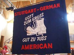
Don't forget to look for the Club Flag and sign your name in the book.
Important: The event list below is updated weekly. (Status of the information: See copyright notice at the end of the page.)
Please visit this website a few days before attending one of the events to ensure that your information is still up to date.
Or: All dates as ICal-address. - Subscribe our events list for free with your calendar app!
Show all walks on a map
More IVV Events
Note: Explanations for Volksmarching and German Region Abbreviations on the DVV website can be found here
Upcoming DVV-Walks in Germany (German)
Permanent DVV-Walking-Trails in Germany (German)
International Walking Events on the IVV website
Upcoming DVV-Walks in Germany (German)
Permanent DVV-Walking-Trails in Germany (German)
International Walking Events on the IVV website
All hosted and guided IVV Walks in Baden-Württemberg
June 2026
Saturday, 20 June 2026 - Vogtsburg-Oberbergen / Wanderfreunde Vogtsburg im Kaiserstuhl e.V. / Baden-Württemberg
Trails: 6/11 km - Start: 14:00 - 19:00 hours - End: 22:00 hours - Start Address: Winzergenossenschaft Oberbergen, Badbergstraße 2, 79235 Vogtsburg-Oberbergen - GPS coordinates: 48.09433,7.65165 - OpenStreetMap - Google Maps - Public Transport Stop: Oberbergen Winzergenossenschaft, Vogtsburg im Kais (Deutsche Bahn) (0 minutes footway) - Download Flyer
Trails: 6/11 km - Start: 14:00 - 19:00 hours - End: 22:00 hours - Start Address: Winzergenossenschaft Oberbergen, Badbergstraße 2, 79235 Vogtsburg-Oberbergen - GPS coordinates: 48.09433,7.65165 - OpenStreetMap - Google Maps - Public Transport Stop: Oberbergen Winzergenossenschaft, Vogtsburg im Kais (Deutsche Bahn) (0 minutes footway) - Download Flyer
Saturday, 20 June 2026 - Vogtsburg-Oberbergen / Wanderfreunde Vogtsburg im Kaiserstuhl e.V. / Baden-Württemberg - GPS-DVV-Walk - Smart phone with GPS-App needed!
Trails: 20 km - Start: 14:00 - 18:00 hours - End: 22:00 hours - Start Address: Winzergenossenschaft Oberbergen, Badbergstraße 2, 79235 Vogtsburg-Oberbergen - GPS coordinates: 48.09433,7.65165 - OpenStreetMap - Google Maps - Public Transport Stop: Oberbergen Winzergenossenschaft, Vogtsburg im Kais (Deutsche Bahn) (0 minutes footway) - Download Flyer
Trails: 20 km - Start: 14:00 - 18:00 hours - End: 22:00 hours - Start Address: Winzergenossenschaft Oberbergen, Badbergstraße 2, 79235 Vogtsburg-Oberbergen - GPS coordinates: 48.09433,7.65165 - OpenStreetMap - Google Maps - Public Transport Stop: Oberbergen Winzergenossenschaft, Vogtsburg im Kais (Deutsche Bahn) (0 minutes footway) - Download Flyer
Saturday, 20 June 2026 - Renchen / Wanderfreunde Reichenbach-Gengenbach e.V. / Baden-Württemberg - Guided Volksmarch
Trails: 6/10 km - Start: 10:00 hours - Start Address: Friedhofsparkplatz, Friedhofstraße 40, 77871 Renchen - Club Homepage - GPS coordinates: 48.58526,8.01535 - OpenStreetMap - Google Maps - Public Transport Stop: Renchen (Deutsche Bahn) (17 minutes footway)
Trails: 6/10 km - Start: 10:00 hours - Start Address: Friedhofsparkplatz, Friedhofstraße 40, 77871 Renchen - Club Homepage - GPS coordinates: 48.58526,8.01535 - OpenStreetMap - Google Maps - Public Transport Stop: Renchen (Deutsche Bahn) (17 minutes footway)
Sunday, 21 June 2026 - Vogtsburg-Oberbergen / Wanderfreunde Vogtsburg im Kaiserstuhl e.V. / Baden-Württemberg
Trails: 6/11 km - Start: 07:00 - 14:00 hours - End: 18:00 hours - Start Address: Winzergenossenschaft Oberbergen, Badbergstraße 2, 79235 Vogtsburg-Oberbergen - GPS coordinates: 48.09433,7.65165 - OpenStreetMap - Google Maps - Public Transport Stop: Oberbergen Winzergenossenschaft, Vogtsburg im Kais (Deutsche Bahn) (0 minutes footway) - Download Flyer
Trails: 6/11 km - Start: 07:00 - 14:00 hours - End: 18:00 hours - Start Address: Winzergenossenschaft Oberbergen, Badbergstraße 2, 79235 Vogtsburg-Oberbergen - GPS coordinates: 48.09433,7.65165 - OpenStreetMap - Google Maps - Public Transport Stop: Oberbergen Winzergenossenschaft, Vogtsburg im Kais (Deutsche Bahn) (0 minutes footway) - Download Flyer
Sunday, 21 June 2026 - Vogtsburg-Oberbergen / Wanderfreunde Vogtsburg im Kaiserstuhl e.V. / Baden-Württemberg - GPS-DVV-Walk - Smart phone with GPS-App needed!
Trails: 20 km - Start: 07:00 - 13:00 hours - End: 18:00 hours - Start Address: Winzergenossenschaft Oberbergen, Badbergstraße 2, 79235 Vogtsburg-Oberbergen - GPS coordinates: 48.09433,7.65165 - OpenStreetMap - Google Maps - Public Transport Stop: Oberbergen Winzergenossenschaft, Vogtsburg im Kais (Deutsche Bahn) (0 minutes footway) - Download Flyer
Trails: 20 km - Start: 07:00 - 13:00 hours - End: 18:00 hours - Start Address: Winzergenossenschaft Oberbergen, Badbergstraße 2, 79235 Vogtsburg-Oberbergen - GPS coordinates: 48.09433,7.65165 - OpenStreetMap - Google Maps - Public Transport Stop: Oberbergen Winzergenossenschaft, Vogtsburg im Kais (Deutsche Bahn) (0 minutes footway) - Download Flyer
Sunday, 28 June 2026 - Ittlingen / Musik-Wanderverein Edelweiß e.V. Ittlingen / Baden-Württemberg - Stammtisch
Trails: 5/10 km - Start: 08:00 - 14:00 hours - End: 17:00 hours - Start Address: Festhalle, Hauptstraße 105, 74930 Ittlingen - Club Homepage - GPS coordinates: 49.19379,8.93478 - OpenStreetMap - Google Maps - Public Transport Stop: Ittlingen (Deutsche Bahn) (9 minutes footway) - Download Flyer
Trails: 5/10 km - Start: 08:00 - 14:00 hours - End: 17:00 hours - Start Address: Festhalle, Hauptstraße 105, 74930 Ittlingen - Club Homepage - GPS coordinates: 49.19379,8.93478 - OpenStreetMap - Google Maps - Public Transport Stop: Ittlingen (Deutsche Bahn) (9 minutes footway) - Download Flyer
July 2026
Sunday, 05 July 2026 - Reichenbach-Gengenbach / Wanderfreunde Reichenbach-Gengenbach e.V. / Baden-Württemberg - Guided Volksmarch
Trails: 6/13/25 km - Start: 10:00 hours - Start Address: Vereinsheim, Reichenbachtalstraße 47, 77723 Reichenbach-Gengenbach - Club Homepage - GPS coordinates: 48.42866,8.01640 - OpenStreetMap - Google Maps - Public Transport Stop: Gengenbach (Deutsche Bahn) (45 minutes footway)
Trails: 6/13/25 km - Start: 10:00 hours - Start Address: Vereinsheim, Reichenbachtalstraße 47, 77723 Reichenbach-Gengenbach - Club Homepage - GPS coordinates: 48.42866,8.01640 - OpenStreetMap - Google Maps - Public Transport Stop: Gengenbach (Deutsche Bahn) (45 minutes footway)
Saturday, 11 July 2026 - Ehingen an der Donau - Permanent walking trail with brewery tour and brewery restaurant visit / Baden-Württemberg - Trip - Please read the info in the flyer.
Trails: 5/15 km - Start: 10:00 hours - End: 16:30 hours - Start Address: Ehingen (Donau) Bahnhof, Am Bahnhof 1, 89584 Ehingen (Donau) - GPS coordinates: 48.28547,9.72458 - OpenStreetMap - Google Maps - Public Transport Stop: Ehingen (Donau) (Deutsche Bahn) (0 minutes footway)
Price: 20 Euro (plus Restaurant)
Please register: Erica Kelly & Theresa Cole - Download Flyer
Sunday, 12 July 2026 - Eisenbach / Wanderfreunde Titisee-Neustadt e.V. / Baden-Württemberg
Trails: 6/10 km - Start: 07:30 - 12:00 hours - End: 15:00 hours - Start Address: Wolfwinkelhalle Eisenbach, Bei der Kirche 6, 79871 Eisenbach - Club Homepage - GPS coordinates: 47.95850,8.26387 - OpenStreetMap - Google Maps - Download Flyer
Trails: 6/10 km - Start: 07:30 - 12:00 hours - End: 15:00 hours - Start Address: Wolfwinkelhalle Eisenbach, Bei der Kirche 6, 79871 Eisenbach - Club Homepage - GPS coordinates: 47.95850,8.26387 - OpenStreetMap - Google Maps - Download Flyer
Saturday, 18 July 2026 - Weilheim-Remetschwiel / Sport- und Wandergruppe Haagwald e.V. / Baden-Württemberg
Trails: 6/10 km - Start: 08:00 - 14:00 hours - Start Address: Haagwaldhalle Remetschwiel, Waldhausstraße 3, 79809 Weilheim-Remetschwiel - GPS coordinates: 47.67984,8.15329 - OpenStreetMap - Google Maps - Public Transport Stop: Remetschwiel Haagwaldhalle, Weilheim (Kreis Waldsh (Deutsche Bahn) (1 minutes footway)
Trails: 6/10 km - Start: 08:00 - 14:00 hours - Start Address: Haagwaldhalle Remetschwiel, Waldhausstraße 3, 79809 Weilheim-Remetschwiel - GPS coordinates: 47.67984,8.15329 - OpenStreetMap - Google Maps - Public Transport Stop: Remetschwiel Haagwaldhalle, Weilheim (Kreis Waldsh (Deutsche Bahn) (1 minutes footway)
Sunday, 19 July 2026 - Weilheim-Remetschwiel / Sport- und Wandergruppe Haagwald e.V. / Baden-Württemberg
Trails: 6/10 km - Start: 08:00 - 14:00 hours - Start Address: Haagwaldhalle Remetschwiel, Waldhausstraße 3, 79809 Weilheim-Remetschwiel - GPS coordinates: 47.67984,8.15329 - OpenStreetMap - Google Maps - Public Transport Stop: Remetschwiel Haagwaldhalle, Weilheim (Kreis Waldsh (Deutsche Bahn) (1 minutes footway)
Trails: 6/10 km - Start: 08:00 - 14:00 hours - Start Address: Haagwaldhalle Remetschwiel, Waldhausstraße 3, 79809 Weilheim-Remetschwiel - GPS coordinates: 47.67984,8.15329 - OpenStreetMap - Google Maps - Public Transport Stop: Remetschwiel Haagwaldhalle, Weilheim (Kreis Waldsh (Deutsche Bahn) (1 minutes footway)
Saturday, 25 July 2026 - Crailsheim-Jagstheim / Wanderfreunde Crailsheim e.V. / Baden-Württemberg - Stammtisch
Trails: 6/11/21/30 km - Start: 06:00 - 13:00 hours - End: 17:00 hours - Start Address: Jagstauenhalle, Jagstheimer Hauptstraße 157, 74564 Crailsheim-Jagstheim - Club Homepage - GPS coordinates: 49.08953,10.06458 - OpenStreetMap - Google Maps - Public Transport Stop: Jagstheim Ortsmitte, Crailsheim (Deutsche Bahn) (4 minutes footway or Shuttle service only if reservated from railway stop Crailsheim) - Download Flyer
Trails: 6/11/21/30 km - Start: 06:00 - 13:00 hours - End: 17:00 hours - Start Address: Jagstauenhalle, Jagstheimer Hauptstraße 157, 74564 Crailsheim-Jagstheim - Club Homepage - GPS coordinates: 49.08953,10.06458 - OpenStreetMap - Google Maps - Public Transport Stop: Jagstheim Ortsmitte, Crailsheim (Deutsche Bahn) (4 minutes footway or Shuttle service only if reservated from railway stop Crailsheim) - Download Flyer
Sunday, 26 July 2026 - Crailsheim-Jagstheim / Wanderfreunde Crailsheim e.V. / Baden-Württemberg - Stammtisch
Trails: 6/11/21/30 km - Start: 06:00 - 13:00 hours - End: 17:00 hours - Start Address: Jagstauenhalle, Jagstheimer Hauptstraße 157, 74564 Crailsheim-Jagstheim - Club Homepage - GPS coordinates: 49.08953,10.06458 - OpenStreetMap - Google Maps - Public Transport Stop: Jagstheim Ortsmitte, Crailsheim (Deutsche Bahn) (4 minutes footway or Shuttle service only if reservated from railway stop Crailsheim) - Download Flyer
Trails: 6/11/21/30 km - Start: 06:00 - 13:00 hours - End: 17:00 hours - Start Address: Jagstauenhalle, Jagstheimer Hauptstraße 157, 74564 Crailsheim-Jagstheim - Club Homepage - GPS coordinates: 49.08953,10.06458 - OpenStreetMap - Google Maps - Public Transport Stop: Jagstheim Ortsmitte, Crailsheim (Deutsche Bahn) (4 minutes footway or Shuttle service only if reservated from railway stop Crailsheim) - Download Flyer
Sunday, 26 July 2026 - Lenzkirch / Wanderfreunde Titisee-Neustadt e.V. / Baden-Württemberg - Guided Volksmarch
Trails: 5/10 km - Start: 10:00 hours - Start Address: Café-Bäckerei Wiest, Kirchplatz 2, 79853 Lenzkirch - Club Homepage - GPS coordinates: 47.86844,8.20209 - OpenStreetMap - Google Maps - Public Transport Stop: Brunnen, Lenzkirch (Deutsche Bahn) (2 minutes footway) - Download Flyer
Trails: 5/10 km - Start: 10:00 hours - Start Address: Café-Bäckerei Wiest, Kirchplatz 2, 79853 Lenzkirch - Club Homepage - GPS coordinates: 47.86844,8.20209 - OpenStreetMap - Google Maps - Public Transport Stop: Brunnen, Lenzkirch (Deutsche Bahn) (2 minutes footway) - Download Flyer
August 2026
Saturday, 01 August 2026 - Kämpfelbach-Ersingen / Wanderfreunde Kämpfelbachtal e.V. / Baden-Württemberg
Trails: 5/10/20 km - Start: 08:00 - 13:00 hours - End: 16:00 hours - Start Address: Turn- und Festhalle, Turnstraße 4, 75236 Kämpfelbach-Ersingen - GPS coordinates: 48.93280,8.63073 - OpenStreetMap - Google Maps - Public Transport Stop: Ersingen West (Deutsche Bahn) (4 minutes footway)
Trails: 5/10/20 km - Start: 08:00 - 13:00 hours - End: 16:00 hours - Start Address: Turn- und Festhalle, Turnstraße 4, 75236 Kämpfelbach-Ersingen - GPS coordinates: 48.93280,8.63073 - OpenStreetMap - Google Maps - Public Transport Stop: Ersingen West (Deutsche Bahn) (4 minutes footway)
Saturday, 01 August 2026 - Gengenbach / Wanderfreunde Reichenbach-Gengenbach e.V. / Baden-Württemberg - Guided Volksmarch
Trails: 3 km - Start: 20:00 hours - Start Address: Parking lot Kinzigtalhalle, Brambachstraße 1, 77723 Gengenbach - Club Homepage - GPS coordinates: 48.39721,8.02177 - OpenStreetMap - Google Maps - Public Transport Stop: Gengenbach (Deutsche Bahn) (17 minutes footway)
Trails: 3 km - Start: 20:00 hours - Start Address: Parking lot Kinzigtalhalle, Brambachstraße 1, 77723 Gengenbach - Club Homepage - GPS coordinates: 48.39721,8.02177 - OpenStreetMap - Google Maps - Public Transport Stop: Gengenbach (Deutsche Bahn) (17 minutes footway)
Sunday, 02 August 2026 - Kämpfelbach-Ersingen / Wanderfreunde Kämpfelbachtal e.V. / Baden-Württemberg
Trails: 5/10/20 km - Start: 07:30 - 13:00 hours - End: 16:00 hours - Start Address: Turn- und Festhalle, Turnstraße 4, 75236 Kämpfelbach-Ersingen - GPS coordinates: 48.93280,8.63073 - OpenStreetMap - Google Maps - Public Transport Stop: Ersingen West (Deutsche Bahn) (4 minutes footway)
Trails: 5/10/20 km - Start: 07:30 - 13:00 hours - End: 16:00 hours - Start Address: Turn- und Festhalle, Turnstraße 4, 75236 Kämpfelbach-Ersingen - GPS coordinates: 48.93280,8.63073 - OpenStreetMap - Google Maps - Public Transport Stop: Ersingen West (Deutsche Bahn) (4 minutes footway)
Saturday, 08 August 2026 - Neckargerach / Kraichgau-Wanderer Grombach e.V. / Baden-Württemberg - Guided Volksmarch - Marathon - Please read the info in the flyer.
Trails: 42 km - Start: 06:00 hours - End: 18:00 hours - Start Address: S-Bahn Parking lot at the Bahnhof Neckargerach, Bahnhofstraße 29, 69437 Neckargerach - GPS coordinates: 49.39827,9.07441 - OpenStreetMap - Google Maps - Public Transport Stop: Neckargerach (Deutsche Bahn) (0 minutes footway) - Download Flyer
Trails: 42 km - Start: 06:00 hours - End: 18:00 hours - Start Address: S-Bahn Parking lot at the Bahnhof Neckargerach, Bahnhofstraße 29, 69437 Neckargerach - GPS coordinates: 49.39827,9.07441 - OpenStreetMap - Google Maps - Public Transport Stop: Neckargerach (Deutsche Bahn) (0 minutes footway) - Download Flyer
Saturday, 15 August 2026 - Reichenbach-Gengenbach / Wanderfreunde Reichenbach-Gengenbach e.V. / Baden-Württemberg - Guided Volksmarch
Trails: 7/12 km - Start: 09:30 hours - Start Address: Vereinsheim, Reichenbachtalstraße 47, 77723 Reichenbach-Gengenbach - Club Homepage - GPS coordinates: 48.42866,8.01640 - OpenStreetMap - Google Maps - Public Transport Stop: Gengenbach (Deutsche Bahn) (45 minutes footway)
Trails: 7/12 km - Start: 09:30 hours - Start Address: Vereinsheim, Reichenbachtalstraße 47, 77723 Reichenbach-Gengenbach - Club Homepage - GPS coordinates: 48.42866,8.01640 - OpenStreetMap - Google Maps - Public Transport Stop: Gengenbach (Deutsche Bahn) (45 minutes footway)
September 2026
Saturday, 05 September 2026 - Erstein / Les Marcheurs du Sucre / France
Saturday, 05 September 2026 - Freiamt-Mußbach / Motorsport Racing-Team Freiamt e.V. / Baden-Württemberg - Guided Volksmarch - Marathon
Trails: 42 km - Start: 07:00 hours - Start Address: Clubhaus Motorsport Racing-Team, Am Bus 57, 79348 Freiamt-Mußbach - Club Homepage - GPS coordinates: 48.17342,7.89359 - OpenStreetMap - Google Maps
Trails: 42 km - Start: 07:00 hours - Start Address: Clubhaus Motorsport Racing-Team, Am Bus 57, 79348 Freiamt-Mußbach - Club Homepage - GPS coordinates: 48.17342,7.89359 - OpenStreetMap - Google Maps
Sunday, 06 September 2026 - Freiamt-Mußbach / Motorsport Racing-Team Freiamt e.V. / Baden-Württemberg
Trails: 6/12/16 km - Start: 07:00 - 13:00 hours - Start Address: Festzelt at the Clubhaus Motorsport Racing-Team, Am Bus 57, 79348 Freiamt-Mußbach - Club Homepage - GPS coordinates: 48.17342,7.89359 - OpenStreetMap - Google Maps
Trails: 6/12/16 km - Start: 07:00 - 13:00 hours - Start Address: Festzelt at the Clubhaus Motorsport Racing-Team, Am Bus 57, 79348 Freiamt-Mußbach - Club Homepage - GPS coordinates: 48.17342,7.89359 - OpenStreetMap - Google Maps
Sunday, 06 September 2026 - Erstein / Les Marcheurs du Sucre / France
Saturday, 12 September 2026 - Ottenhöfen / Wanderfreunde Reichenbach-Gengenbach e.V. / Baden-Württemberg - Guided Volksmarch
Trails: 7/14 km - Start: 10:00 hours - Start Address: Kurpark Ottenhöfen, Am Bahnhof 1, 77883 Ottenhöfen - Club Homepage - GPS coordinates: 48.56713,8.15116 - OpenStreetMap - Google Maps - Public Transport Stop: Ottenhöfen (Deutsche Bahn) (0 minutes footway)
Trails: 7/14 km - Start: 10:00 hours - Start Address: Kurpark Ottenhöfen, Am Bahnhof 1, 77883 Ottenhöfen - Club Homepage - GPS coordinates: 48.56713,8.15116 - OpenStreetMap - Google Maps - Public Transport Stop: Ottenhöfen (Deutsche Bahn) (0 minutes footway)
Sunday, 13 September 2026 - Hildrizhausen / Wandergruppe Schönbuch-Hildrizhausen e.V. / Baden-Württemberg - Stammtisch
Trails: 6/12 km - Start: 07:30 - 13:00 hours - Start Address: Schönbuchhalle, Im Sommerfeld 4, 71157 Hildrizhausen - GPS coordinates: 48.62224,8.97435 - OpenStreetMap - Google Maps - Public Transport Stop: Altdorfer Straße, Hildrizhausen (Deutsche Bahn) (7 minutes footway)
Trails: 6/12 km - Start: 07:30 - 13:00 hours - Start Address: Schönbuchhalle, Im Sommerfeld 4, 71157 Hildrizhausen - GPS coordinates: 48.62224,8.97435 - OpenStreetMap - Google Maps - Public Transport Stop: Altdorfer Straße, Hildrizhausen (Deutsche Bahn) (7 minutes footway)
Sunday, 13 September 2026 - Berghaupten / Wanderfreunde Berghaupten e.V. / Baden-Württemberg
Trails: 5/12 km - Start: 08:00 - 13:30 hours - End: 17:00 hours - Start Address: Schlosswaldhalle, Stiegelmattstraße 4, 77791 Berghaupten - Club Homepage - GPS coordinates: 48.40981,7.98763 - OpenStreetMap - Google Maps - Public Transport Stop: Gengenbach (Deutsche Bahn) (35 minutes footway)
Trails: 5/12 km - Start: 08:00 - 13:30 hours - End: 17:00 hours - Start Address: Schlosswaldhalle, Stiegelmattstraße 4, 77791 Berghaupten - Club Homepage - GPS coordinates: 48.40981,7.98763 - OpenStreetMap - Google Maps - Public Transport Stop: Gengenbach (Deutsche Bahn) (35 minutes footway)
Saturday, 19 September 2026 - Bad Rappenau-Grombach / Kraichgau-Wanderer Grombach e.V. / Baden-Württemberg - Guided Volksmarch
Trails: 21 km - Start: 09:00 hours - End: 13:30 hours - Start Address: Züchterheim, Mühlstraße 12, 74906 Bad Rappenau-Grombach - GPS coordinates: 49.22419,8.98495 - OpenStreetMap - Google Maps - Public Transport Stop: Grombach (Deutsche Bahn) (10 minutes footway) - Download Flyer
Trails: 21 km - Start: 09:00 hours - End: 13:30 hours - Start Address: Züchterheim, Mühlstraße 12, 74906 Bad Rappenau-Grombach - GPS coordinates: 49.22419,8.98495 - OpenStreetMap - Google Maps - Public Transport Stop: Grombach (Deutsche Bahn) (10 minutes footway) - Download Flyer
Saturday, 19 September 2026 - Bad Rappenau-Grombach / Kraichgau-Wanderer Grombach e.V. / Baden-Württemberg - Guided Volksmarch
Trails: 12 km - Start: 09:30 hours - End: 12:30 hours - Start Address: Züchterheim, Mühlstraße 12, 74906 Bad Rappenau-Grombach - GPS coordinates: 49.22419,8.98495 - OpenStreetMap - Google Maps - Public Transport Stop: Grombach (Deutsche Bahn) (10 minutes footway) - Download Flyer
Trails: 12 km - Start: 09:30 hours - End: 12:30 hours - Start Address: Züchterheim, Mühlstraße 12, 74906 Bad Rappenau-Grombach - GPS coordinates: 49.22419,8.98495 - OpenStreetMap - Google Maps - Public Transport Stop: Grombach (Deutsche Bahn) (10 minutes footway) - Download Flyer
Saturday, 19 September 2026 - Bad Rappenau-Grombach / Kraichgau-Wanderer Grombach e.V. / Baden-Württemberg - Guided Volksmarch
Trails: 6 km - Start: 09:30 hours - End: 11:00 hours - Start Address: Züchterheim, Mühlstraße 12, 74906 Bad Rappenau-Grombach - GPS coordinates: 49.22419,8.98495 - OpenStreetMap - Google Maps - Public Transport Stop: Grombach (Deutsche Bahn) (10 minutes footway) - Download Flyer
Trails: 6 km - Start: 09:30 hours - End: 11:00 hours - Start Address: Züchterheim, Mühlstraße 12, 74906 Bad Rappenau-Grombach - GPS coordinates: 49.22419,8.98495 - OpenStreetMap - Google Maps - Public Transport Stop: Grombach (Deutsche Bahn) (10 minutes footway) - Download Flyer
Saturday, 19 September 2026 - Friedenweiler-Rötenbach / Wanderfreunde Titisee-Neustadt e.V. / Baden-Württemberg - Guided Volksmarch
Trails: 6/11 km - Start: 10:00 hours - Start Address: Gastwirtschaft Gaspedal, Sportplatzweg 11a, 79877 Friedenweiler-Rötenbach - Club Homepage - GPS coordinates: 47.88534,8.28656 - OpenStreetMap - Google Maps - Download Flyer
Trails: 6/11 km - Start: 10:00 hours - Start Address: Gastwirtschaft Gaspedal, Sportplatzweg 11a, 79877 Friedenweiler-Rötenbach - Club Homepage - GPS coordinates: 47.88534,8.28656 - OpenStreetMap - Google Maps - Download Flyer
Sunday, 20 September 2026 - Filderstadt-Plattenhardt / Stuttgart German-American Wandering Club / Baden-Württemberg - Our Annual Walk
Trails: 5/10/21 km - Start: 08:00 - 14:00 hours - End: 17:00 hours - Start Address: Weilerhauhalle, Weilerhau 2, 70794 Filderstadt-Plattenhardt - Club Homepage - GPS coordinates: 48.65406,9.18777 - OpenStreetMap - Google Maps - Public Transport Stop: Plattenhardt Weilerhau, Filderstadt (Deutsche Bahn) (4 minutes footway) - Download Flyer
Trails: 5/10/21 km - Start: 08:00 - 14:00 hours - End: 17:00 hours - Start Address: Weilerhauhalle, Weilerhau 2, 70794 Filderstadt-Plattenhardt - Club Homepage - GPS coordinates: 48.65406,9.18777 - OpenStreetMap - Google Maps - Public Transport Stop: Plattenhardt Weilerhau, Filderstadt (Deutsche Bahn) (4 minutes footway) - Download Flyer
Sunday, 27 September 2026 - Ittlingen / Musik-Wanderverein Edelweiß e.V. Ittlingen / Baden-Württemberg - Stammtisch
Trails: 5/10/20 km - Start: 07:00 - 13:00 hours - End: 17:00 hours - Start Address: Festhalle, Hauptstraße 105, 74930 Ittlingen - Club Homepage - GPS coordinates: 49.19379,8.93478 - OpenStreetMap - Google Maps - Public Transport Stop: Ittlingen (Deutsche Bahn) (9 minutes footway) - Download Flyer
Trails: 5/10/20 km - Start: 07:00 - 13:00 hours - End: 17:00 hours - Start Address: Festhalle, Hauptstraße 105, 74930 Ittlingen - Club Homepage - GPS coordinates: 49.19379,8.93478 - OpenStreetMap - Google Maps - Public Transport Stop: Ittlingen (Deutsche Bahn) (9 minutes footway) - Download Flyer
Sunday, 27 September 2026 - Allmersbach im Tal / Baden-Württemberg - Guided Volksmarch
October 2026
Saturday, 03 October 2026 - Reichenbach-Gengenbach / Wanderfreunde Reichenbach-Gengenbach e.V. / Baden-Württemberg - Guided Volksmarch - (Germany walks - Germany helps)
Trails: 6/12 km - Start: 10:00 hours - Start Address: Vereinsheim, Reichenbachtalstraße 47, 77723 Reichenbach-Gengenbach - Club Homepage - GPS coordinates: 48.42866,8.01640 - OpenStreetMap - Google Maps - Public Transport Stop: Gengenbach (Deutsche Bahn) (45 minutes footway)
Trails: 6/12 km - Start: 10:00 hours - Start Address: Vereinsheim, Reichenbachtalstraße 47, 77723 Reichenbach-Gengenbach - Club Homepage - GPS coordinates: 48.42866,8.01640 - OpenStreetMap - Google Maps - Public Transport Stop: Gengenbach (Deutsche Bahn) (45 minutes footway)
Saturday, 03 October 2026 - Bad Wurzach-Eintürnenberg / Wanderfreunde Vogt / Baden-Württemberg - Guided Volksmarch - (Germany walks - Germany helps)
Trails: 6/10 km - Start: 10:00 hours - Start Address: Eintürnenberg, Klarenstraße 1, 88410 Bad Wurzach-Eintürnenberg - GPS coordinates: 47.84770,9.83772 - OpenStreetMap - Google Maps
Trails: 6/10 km - Start: 10:00 hours - Start Address: Eintürnenberg, Klarenstraße 1, 88410 Bad Wurzach-Eintürnenberg - GPS coordinates: 47.84770,9.83772 - OpenStreetMap - Google Maps
Saturday, 10 October 2026 - Bad Rappenau-Grombach / Kraichgau-Wanderer Grombach e.V. / Baden-Württemberg - Guided Volksmarch
Trails: 20 km - Start: 09:00 hours - End: 13:30 hours - Start Address: Züchterheim, Mühlstraße 12, 74906 Bad Rappenau-Grombach - GPS coordinates: 49.22419,8.98495 - OpenStreetMap - Google Maps - Public Transport Stop: Grombach (Deutsche Bahn) (10 minutes footway) - Download Flyer
Trails: 20 km - Start: 09:00 hours - End: 13:30 hours - Start Address: Züchterheim, Mühlstraße 12, 74906 Bad Rappenau-Grombach - GPS coordinates: 49.22419,8.98495 - OpenStreetMap - Google Maps - Public Transport Stop: Grombach (Deutsche Bahn) (10 minutes footway) - Download Flyer
Saturday, 10 October 2026 - Bad Rappenau-Grombach / Kraichgau-Wanderer Grombach e.V. / Baden-Württemberg - Guided Volksmarch
Trails: 10 km - Start: 09:30 hours - End: 12:00 hours - Start Address: Züchterheim, Mühlstraße 12, 74906 Bad Rappenau-Grombach - GPS coordinates: 49.22419,8.98495 - OpenStreetMap - Google Maps - Public Transport Stop: Grombach (Deutsche Bahn) (10 minutes footway) - Download Flyer
Trails: 10 km - Start: 09:30 hours - End: 12:00 hours - Start Address: Züchterheim, Mühlstraße 12, 74906 Bad Rappenau-Grombach - GPS coordinates: 49.22419,8.98495 - OpenStreetMap - Google Maps - Public Transport Stop: Grombach (Deutsche Bahn) (10 minutes footway) - Download Flyer
Saturday, 10 October 2026 - Bad Rappenau-Grombach / Kraichgau-Wanderer Grombach e.V. / Baden-Württemberg - Guided Volksmarch
Trails: 6 km - Start: 09:30 hours - End: 11:00 hours - Start Address: Züchterheim, Mühlstraße 12, 74906 Bad Rappenau-Grombach - GPS coordinates: 49.22419,8.98495 - OpenStreetMap - Google Maps - Public Transport Stop: Grombach (Deutsche Bahn) (10 minutes footway) - Download Flyer
Trails: 6 km - Start: 09:30 hours - End: 11:00 hours - Start Address: Züchterheim, Mühlstraße 12, 74906 Bad Rappenau-Grombach - GPS coordinates: 49.22419,8.98495 - OpenStreetMap - Google Maps - Public Transport Stop: Grombach (Deutsche Bahn) (10 minutes footway) - Download Flyer
Saturday, 10 October 2026 - Renningen / Baden-Württemberg - Guided Volksmarch
Sunday, 25 October 2026 - Schuttertal-Dörlinbach / Radfahrverein Schutterbund Dörlinbach 1907 e.V. / Baden-Württemberg
Trails: 5/10 km - Start: 06:30 - 14:00 hours - Start Address: Festhalle Dörlinbach, Blumenstraße 1, 77978 Schuttertal-Dörlinbach - GPS coordinates: 48.24586,7.95355 - OpenStreetMap - Google Maps
Trails: 5/10 km - Start: 06:30 - 14:00 hours - Start Address: Festhalle Dörlinbach, Blumenstraße 1, 77978 Schuttertal-Dörlinbach - GPS coordinates: 48.24586,7.95355 - OpenStreetMap - Google Maps
November 2026
Sunday, 01 November 2026 - Dürrn / Baden-Württemberg - Stammtisch
Sunday, 01 November 2026 - Reichenbach-Gengenbach / Wanderfreunde Reichenbach-Gengenbach e.V. / Baden-Württemberg - Guided Volksmarch
Trails: 6/10 km - Start: 10:00 hours - Start Address: Vereinsheim, Reichenbachtalstraße 47, 77723 Reichenbach-Gengenbach - Club Homepage - GPS coordinates: 48.42866,8.01640 - OpenStreetMap - Google Maps - Public Transport Stop: Gengenbach (Deutsche Bahn) (45 minutes footway)
Trails: 6/10 km - Start: 10:00 hours - Start Address: Vereinsheim, Reichenbachtalstraße 47, 77723 Reichenbach-Gengenbach - Club Homepage - GPS coordinates: 48.42866,8.01640 - OpenStreetMap - Google Maps - Public Transport Stop: Gengenbach (Deutsche Bahn) (45 minutes footway)
Monday, 02 November 2026 - Stetten am Heuchelberg / Baden-Württemberg
Sunday, 08 November 2026 - Vogtsburg im Kaiserstuhl / Baden-Württemberg - Guided Volksmarch
Sunday, 15 November 2026 - Vorbachzimmern / Baden-Württemberg
Saturday, 21 November 2026 - Ramstein-Roadrunners / Rheinland-Pfalz
Sunday, 22 November 2026 - Ramstein-Roadrunners / Rheinland-Pfalz
Sunday, 29 November 2026 - Ketsch / Baden-Württemberg
December 2026
Saturday, 12 December 2026 - Reichenbach-Gengenbach / Wanderfreunde Reichenbach-Gengenbach e.V. / Baden-Württemberg - Guided Volksmarch
Trails: 7/12 km - Start: 14:00 hours - Start Address: Vereinsheim, Reichenbachtalstraße 47, 77723 Reichenbach-Gengenbach - Club Homepage - GPS coordinates: 48.42866,8.01640 - OpenStreetMap - Google Maps - Public Transport Stop: Gengenbach (Deutsche Bahn) (45 minutes footway)
Trails: 7/12 km - Start: 14:00 hours - Start Address: Vereinsheim, Reichenbachtalstraße 47, 77723 Reichenbach-Gengenbach - Club Homepage - GPS coordinates: 48.42866,8.01640 - OpenStreetMap - Google Maps - Public Transport Stop: Gengenbach (Deutsche Bahn) (45 minutes footway)
Sunday, 13 December 2026 - Vogtsburg im Kaiserstuhl / Baden-Württemberg - Guided Volksmarch
January 2027
Friday, 01 January 2027 - Vogtsburg-Burkheim / Wanderfreunde Vogtsburg im Kaiserstuhl e.V. / Baden-Württemberg - Torch Walk
Trails: 6/12 km - Start: 13:00 - 19:00 hours - End: 22:00 hours - Start Address: Lazarus von Schwendi Halle, Rheinstraße 2, 79235 Vogtsburg-Burkheim - GPS coordinates: 48.09944,7.60029 - OpenStreetMap - Google Maps - Public Transport Stop: Burkheim-Bischoffingen (Deutsche Bahn) (15 minutes footway)
Trails: 6/12 km - Start: 13:00 - 19:00 hours - End: 22:00 hours - Start Address: Lazarus von Schwendi Halle, Rheinstraße 2, 79235 Vogtsburg-Burkheim - GPS coordinates: 48.09944,7.60029 - OpenStreetMap - Google Maps - Public Transport Stop: Burkheim-Bischoffingen (Deutsche Bahn) (15 minutes footway)